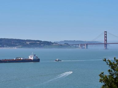
Giant container ships and endangered whales don't mix. When a 1000-foot cargo vessel slams into a 40-ton humpback, the whale loses every single time. For years, the waters just outside the Golden Gate Bridge have been a deadly gauntlet for migrating marine mammals.
We finally have a functional, real-time solution running right in the San Francisco Bay.
The Marine Mammal Center and the Benioff Ocean Science Laboratory teamed up to deploy an advanced acoustic and visual whale tracking system. It gives commercial captains the exact data they need to avoid these catastrophic collisions. It isn't just a passive research project. It's an active safety network. If you care about marine conservation or maritime logistics, you need to understand how this tech changes the game on the West Coast.
The San Francisco Bay Whale Problem Is Worse Than You Think
Most people look out at the Pacific and see a vast, empty ocean. Shipping companies see a crowded highway.
The lanes leading into the Port of Oakland and San Francisco Bay overlap directly with the feeding grounds of humpback whales, blue whales, and critically endangered Pacific coast feeding group gray animals.
Why Traditional Methods Failed
Historically, NOAA and regional wildlife managers relied on seasonal regulations and voluntary speed limits. They asked large ships to slow down to 10 knots during peak migration months.
It didn't work well enough. Here is why.
- Invisible migrations: Whales don't travel on a fixed calendar. Climate shifts change where krill and anchovies show up. Whales follow the food, meaning they often arrive before voluntary speed restrictions start.
- Poor visibility: San Francisco is famous for thick fog. A captain standing on the bridge of a massive vessel cannot see a blowhole break the surface a quarter-mile away in heavy mist.
- Massive stopping distances: A fully loaded container ship takes miles to come to a complete stop or make a major course correction. By the time a crew spots a whale visually, it's usually too late.
Biologists estimate that the number of carcasses washing up on local beaches represents only a tiny fraction of actual ship strikes. Most struck whales sink to the ocean floor unnoticed. The status quo was failing.
Inside the Technology of the New Detection Network
This new initiative expands the Whale Safe project, which already proved its worth in the Santa Barbara Channel. The San Francisco deployment uses a multi-layered approach to create a 24-hour monitoring net. It doesn't rely on just one type of sensor.
Acoustic Buoys Listen for Voices
The core of the system sits beneath the waves. Specialized ocean mooring buoys equipped with underwater microphones, called hydrophones, listen continuously for the distinct vocalizations of blue, fin, and humpback whales.
When a whale sings or clicks, the hydrophone records the audio. An onboard computer uses artificial intelligence algorithms to analyze the sound frequency immediately. If the software matches the audio signature to a whale species, it beams a summary data packet via satellite to researchers on land.
Human acoustic experts review the audio clip to verify the match. This manual check prevents false alarms from boat motors or shifting tides. Once confirmed, the system registers a high-certainty detection event.
Visual Observers and Satellite Models Fill the Gaps
Sound is only part of the equation. Blue whales, for example, are notoriously quiet when they are actively feeding near the surface.
To catch what the hydrophones miss, the network integrates daily sightings from trained observers on whale-watching boats, National Park Service staff, and commercial pilots. They log sightings directly into an app called WhaleAlert.
The system combines these acoustic and visual data points with oceanographic models. By looking at sea surface temperatures, chlorophyll levels, and current patterns, the Benioff Ocean Science Laboratory can predict whale density. They generate a daily "whale presence rating" ranging from low to very high.
Getting Data to the Ship Captains Who Need It
Data is useless if it sits in a university database. The real magic of this network is its communication strategy.
The system broadcasts real-time alerts directly to automated identification systems used by maritime traffic controllers and commercial ship bridges. When a vessel enters the shipping lanes outside San Francisco, the crew receives an immediate update on whale activity.
Imagine driving a semi-truck down a dark highway and getting a dashboard alert that a herd of deer is standing in the road two miles ahead. You naturally take your foot off the gas and watch the shoulders. That's exactly what this network forces shipping crews to do. They slow down to under 10 knots, which reduces the force of a potential impact by over 50% and gives whales time to dive out of harm's way.
Accountability Through Public Shipping Scorecards
This program doesn't just ask nicely. It tracks compliance publicly.
The Whale Safe platform monitors the automatic tracking data of every large commercial transit. It grades shipping lines based on how often their vessels actually slow down when alerts are active.
San Francisco Shipping Lane Compliance Metrics (Sample Data)
------------------------------------------------------------
Speed Zone Type             | Target Speed | Avg Compliance
------------------------------------------------------------
Voluntary Slowdown Zones    | Under 10 kts | 45% - 60%
Whale Safe Alert Active     | Under 10 kts | 80% - 85%
Mandatory Sanctuary Zones   | Under 10 kts | 95%+
When global brands like retailers and manufacturers vet supply chains, they look at these eco-scores. No major shipping company wants its name at the bottom of a public leaderboard showing they routinely run over endangered species. Social pressure and corporate accountability drive behavior change far faster than government memos.
The Road Ahead for West Coast Port Safety
The San Francisco Bay network represents a major win, but it isn't a permanent fix on its own. The ultimate goal is an interconnected digital wall stretching from the southern tip of California all the way to Vancouver.
If you operate a business that relies on maritime freight, ask your logistics partners about their Whale Safe compliance rating. Demand that they adhere to the 10-knot limit in active zones.
If you are a local resident or ocean enthusiast, you can download the WhaleAlert app to contribute data during your own coastal trips. Every logged sighting refines the predictive models and helps keep these massive animals safe in our waters.