British hedgehogs are vanishing from the countryside at a devastating rate, with rural populations plummeting by 30 to 75 percent since 2000. In response, a wave of high-tech conservation initiatives has emerged, deploying artificial intelligence, Earth-observation satellites, and miniature GPS backpacks to track the remaining animals. Yet, while these tools are celebrated as a monumental leap forward for wildlife preservation, they expose a uncomfortable reality. We are spending millions to monitor a catastrophe we already know how to fix, using algorithms to map the precise coordinates of an extinction driven by human neatness and industrial farming.
The crisis is not a mystery that requires advanced data science to solve. The fundamental causes of the hedgehog decline have been thoroughly documented for decades. The destruction of hedgerows, the heavy use of agricultural pesticides that wipe out insect prey, and the fragmentation of suburban gardens by impenetrable wooden fences have turned the British landscape into a minefield for small mammals.
The introduction of technology into this equation changes the scale of data collection, but it does not automatically change the outcome on the ground.
The Myth of Space-Based Tracking
Recent headlines have painted a futuristic picture of conservation, suggesting that scientists are using orbital satellites to watch over Britain's favorite spiky mammals from space. The reality is far more grounded and technically constrained. A European hedgehog measures roughly 20 to 30 centimeters in length. Commercial satellite imagery, even at its most sophisticated, cannot resolve an object that small moving through the undergrowth at night.
Instead, researchers at institutions like the University of Cambridge have been forced to take an indirect approach. Rather than tracking the animals themselves, they use machine learning models to analyze orbital data from the European Space Agency’s Sentinel satellites to map the distribution of bramble patches.
Brambles are the dense, thorny shrubs that provide crucial nesting sites and foraging grounds for rural hedgehogs. By training an AI model on satellite data and combining it with ground-truth observations from citizen science platforms, researchers can identify where suitable habitats still exist.
This is an impressive feat of computational geography. It allows conservationists to see large-scale landscape changes across counties without conducting years of manual surveying. However, mapping a bush from space does not mean there is a hedgehog living under it. A pristine patch of brambles is completely useless if it is surrounded by miles of sterile, pesticide-drenched monoculture farmland or cut off by a high-speed A-road. The technology can identify potential refuges, but it cannot fix the isolation that dooms local populations to genetic stagnation and extinction.
The Blind Spot of the Camera Trap
Closer to the ground, the National Hedgehog Monitoring Programme has deployed networks of trail cameras across parks, woodlands, and farmlands. This initiative addresses a major logistical bottleneck in wildlife biology. A single month of camera deployment across dozens of sites generates hundreds of thousands of images. Manually sorting through these files to find a nocturnal mammal is a grueling task that saps human resources.
Here, AI acts as a digital sieve. Simple machine learning algorithms filter out the noise, automatically deleting blank frames caused by waving grass or capturing passing humans. The remaining images, which actually contain wildlife, are then passed to human volunteers for precise species identification.
This combination of automation and citizen science is highly effective for gathering raw numbers. For the first time, researchers are using the Random Encounter Model to convert simple photo counts into rigorous estimates of population density.
Yet, this data-heavy approach suffers from a profound systemic delay. By the time an AI confirms that a local hedgehog population has dropped below a critical threshold, that population may already be functionally extinct. Monitoring is not active intervention. Knowing the exact percentage of annual decline in a specific East Midlands woodland does nothing to stop the badgers, cars, or lack of beetles that are causing it. We are effectively building the most detailed, data-rich obituary for a species in British history.
The Danger of Urban Disconnection
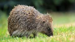
As the countryside becomes increasingly uninhabitable due to intensive agriculture, research shows that hedgehogs are retreating to towns and cities. Urban gardens have become their last remaining sanctuaries. To understand how the animals navigate these human-dominated environments, organizations like Ulster Wildlife have begun fitting hedgehogs with custom-built GPS backpacks.
These tiny trackers weigh less than 20 grams, accounting for a fraction of the weight of an adult hedgehog. Programmed to log a location every ten minutes, they map the secret nocturnal routes of urban males.
The early data from these tracking projects is revealing. It shows animals traversing multiple private properties in a single evening, navigating complex networks of suburban lawns. But it also highlights the immediate hazards they face. The tracking logs capture "heart-in-the-mouth" moments where hedgehogs are forced to cross busy roads to move between isolated green spaces.
This underscores the core limitation of high-tech monitoring. The GPS tag can show a researcher exactly where a hedgehog was killed by a vehicle, or where it turned back because a homeowner installed a new gravel board fence with no gap at the bottom. It proves that our neighborhoods are fundamentally hostile to wildlife movement. The solution to this problem does not require a satellite or an algorithm. It requires a hole saw.
The Cost of Substituting Action with Data
There is an inherent trap in relying too heavily on technology to address ecological crises. Bureaucrats and funding bodies prefer funding high-tech initiatives because they offer clear, quantifiable deliverables. It is easy to write a press release about an AI model or a space-based habitat assessment. It is much harder to implement the sweeping legislative changes needed to alter agricultural practices or reform nationwide planning laws.
This creates a dangerous diversion of resources and attention. While we wait for three-year pilot studies to conclude and deliver their finalized datasets, the physical environment continues to degrade.
The concrete steps required to save the British hedgehog are already known:
- Creating Wildlife Corridors: Cutting 13cm square holes at the base of garden fences to link fragmented urban habitats into continuous "hedgehog highways."
- Restoring Field Boundaries: Providing financial incentives for farmers to maintain wide, uncultivated field margins and dense hedgerows rather than ripping them out.
- Reducing Pesticide Dependency: Limiting the use of slug pellets and systemic insecticides that decimate the invertebrate populations hedgehogs rely on for food.
- Traffic Calming: Implementing targeted infrastructure changes, such as wildlife underpasses, in identified roadkill hotspots.
None of these solutions are hidden waiting to be discovered in a cloud server or an orbital image. They are practical, physical interventions that require political will and community action.
Data has immense value when it guides immediate, well-funded conservation actions. It becomes a liability when it serves as a substitute for those actions. If the deployment of AI and satellites merely confirms what field naturalists have been shouting from the rooftops for the last thirty years, then the technology has served as an expensive diagnostic tool for a patient we are refusing to treat.
Advanced tracking technology should be the mechanism we use to fine-tune our success, not the tool we use to document our failure. If we do not couple these digital insights with immediate, aggressive physical restoration of habitats on the ground, the last British hedgehog will die wearing a very sophisticated, very expensive GPS backpack.
To see how these tracking devices are applied in the field and understand the immediate challenges conservationists face when monitoring urban wildlife populations, you can watch this Ulster Wildlife GPS Tracking Overview, which provides a brief, practical look at how these miniature tracking backpacks are fitted to the animals to map their nightly movements through suburban neighborhoods.