The spatial configuration of East Jerusalem is governed by a highly structured apparatus where municipal planning, asymmetric legal frameworks, and state-subsidized development converge to alter the demographic and physical balance of the city. While conventional analyses interpret municipal property demolitions and resident evictions as localized real estate disputes or isolated municipal enforcement actions, an examination of the systemic data reveals a coordinated, state-backed mechanism designed to maximize sovereign territorial control. This structural process operates via two parallel administrative mechanisms: the asymmetric application of zoning laws to restrict Palestinian construction, and the utilization of discriminatory statutory frameworks to facilitate property transfers to state-aligned settler organizations.
The scaling of this apparatus is clear. Data from the Israeli anti-settlement organization Ir Amim indicates that over 260 homes and structural units were demolished in East Jerusalem in 2025, representing a 70% expansion relative to three years prior. By June 2026, an additional 116 demolitions have been executed. Rather than spontaneous urban enforcement, this acceleration reflects a synchronized deployment of administrative, judicial, and legislative vectors aimed at neutralizing Palestinian urban continuity around the Old City core. Building on this idea, you can also read: Stop Trying to Integrate Yemen into the Gulf Economy.
The Dual-Vector Model of Territorial Control
The structural strategy deployed in East Jerusalem utilizes two distinct operational vectors that target different aspects of property tenure.
                  ┌────────────────────────────────────────┐
                  │ STATE-BACKED URBAN ENGINEERING PIPELINE │
                  └────────────────────────────────────────┘
                                       │
         ┌─────────────────────────────┴─────────────────────────────┐
         ▼                                                           ▼
┌─────────────────────────────────┐                         ┌─────────────────────────────────┐
│     VECTOR 1: URBAN PLANNING    │                         │    VECTOR 2: STATUTORY PROPERTY │
│    & ASYMMETRIC ZONING LAWS     │                         │            TRANSFERS            │
└─────────────────────────────────┘                         └─────────────────────────────────┘
         │                                                           │
         ▼                                                           ▼
┌─────────────────────────────────┐                         ┌─────────────────────────────────┐
│ Designation of land as "Open    │                         │ Application of 1970 Legal Basis │
│ Public Space" or green zones.   │                         │ (Exclusive pre-1948 Jewish claim)│
└─────────────────────────────────┘                         └─────────────────────────────────┘
         │                                                           │
         ▼                                                           ▼
┌─────────────────────────────────┐                         ┌─────────────────────────────────┐
│ Systematic denial of municipal  │                         │ Invalidation of existing        │
│ building permits to residents.  │                         │ residential titles (e.g., Silwan)│
└─────────────────────────────────┘                         └─────────────────────────────────┘
         │                                                           │
         ▼                                                           ▼
┌─────────────────────────────────┐                         ┌─────────────────────────────────┐
│ Execution of administrative     │                         │ Eviction orders and asset       │
│ home demolitions (e.g., Bustan) │                         │ re-allocation to settler groups.│
└─────────────────────────────────┘                         └─────────────────────────────────┘
         │                                                           │
         └─────────────────────────────┬─────────────────────────────┘
                                       ▼
                  ┌────────────────────────────────────────┐
                  │ RESULT: Fragmentation of Palestinian   │
                  │ Cohesion & Continuous Jewish Corridors │
                  └────────────────────────────────────────┘
The first vector leverages administrative planning regulations to target structures built without municipal authorization. The second vector employs property laws to invalidate existing residential titles based on pre-1948 historical claims. Experts at NBC News have provided expertise on this matter.
Vector 1: Asymmetric Zoning and Planning Deficits
The primary mechanism for structural displacement in neighborhoods such as al-Bustan in Silwan is the systematic denial of municipal building permits. Data compiled by the rights group Bimkom highlights this regulatory asymmetry: in 2025, nearly 9,000 building permits were approved for Jewish residents across Jerusalem, whereas fewer than 700 were approved for Palestinian residents, who comprise approximately 40% of the city’s population.
This discrepancy is engineered through specific zoning configurations:
- Green Space and Public Domain Designations: Large swathes of Palestinian-inhabited land are explicitly zoned as open public spaces, national parks, or green areas. Under these designations, the acquisition of legal building permits is structurally impossible.
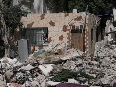
- The King's Garden Initiative: In the al-Bustan area of Silwan, a 30-hectare zone has been designated for the creation of a biblical tourist park. Because a 1977 municipal master plan designated this entire valley as an open public space, the 1,500 residents living in approximately 100 homes face ongoing administrative demolition orders because their structures violate the zoning code.
- The Enforcement Loop: Because demographic growth necessitates physical expansion, residents are forced to construct or expand properties without permits. This triggers administrative or judicial demolition orders, forcing residents to pay for the operational costs of the municipal bulldozers that raze their homes.
Vector 2: Statutory Property Transfers and Judicial Evictions
In contrast to the planning-based demolitions in al-Bustan, neighborhoods like Batan al-Hawah and Sheikh Jarrah are subject to a legal pipeline that transfers existing real estate assets directly to settler organizations like Ateret Cohanim and Elad.
This mechanism relies on a foundational asymmetry within Israeli property legislation:
- The Legal Basis: The Legal and Administrative Matters Law of 1970 allows Israeli citizens to claim property in East Jerusalem if it was owned by Jewish individuals or trusts prior to the 1967 war and subsequent annexation.
- The Reciprocity Deficit: No parallel legal mechanism exists for Palestinian residents to reclaim properties owned prior to 1948 in West Jerusalem or elsewhere within Israel, creating an asymmetric property transfer loop.
- The Execution Phase: Settler organizations locate historical deeds—often from the Ottoman or British Mandate eras—and purchase the rights from the Administrator General. They then initiate eviction lawsuits against long-term Palestinian residents. In March 2026, this pipeline culminated in the forced eviction of 15 families (65 individuals) from Batan al-Hawah after Israel’s Supreme Court ruled against their tenancy status.
The Strategic Macro-Objective: Geopolitical Fragmentations
The structural deployment of these two vectors is designed to achieve a definitive geopolitical configuration. By mapping the geographic locations of these demolitions and evictions, it becomes clear that they are not random municipal actions, but rather a coordinated effort to alter the urban environment.
       [Northern Sector]
       Sheikh Jarrah / Umm Haroun ────────► Block Northern Expansion & Link E-1/Ma'ale Adumim
             │
             ▼
       [The Old City Core] ───────────────► Consolidation of Sovereign Control
             │
             ▼
       [Southern Sector]
       Silwan (al-Bustan / Batan al-Hawah) ► Create Continuous Tourist Corridor Around Old City
This spatial reorganization addresses three key strategic objectives:
1. Disrupting Urban Continuity
The primary geopolitical objective is to prevent the formation of a contiguous, viable Palestinian urban territory that could serve as the capital of a future state. By embedding state-backed enclaves within areas like Silwan and Sheikh Jarrah, the urban landscape is fragmented into isolated zones, complicating future partition or shared governance models.
2. The Tourism Corridor Overlay
The demolition of residential sectors is frequently coupled with archaeological and tourism infrastructure development. The King’s Garden project in al-Bustan, alongside existing developments managed by the Elad organization in the City of David, forms a continuous, state-controlled tourist corridor. This infrastructure integrates historical and biblical narratives into the physical landscape, cementing Israeli control through cultural and tourism presentation.
3. Urban Renewal as a Mechanism for Displacement
A shifting trend in 2025 and 2026 is the utilization of large-scale urban renewal projects to accelerate demographic change. In the Umm Haroun sector of Sheikh Jarrah, municipal planning committees advanced a plan to raze approximately 40 homes to construct a 316-unit residential complex for Jewish tenants.
Under current urban renewal statutes, authorities can approve comprehensive zoning overhauls that bypass traditional tenancy protections. This enables the eviction of residents and the demolition of existing structures in a single administrative action, substituting protracted individual property lawsuits with broad municipal mandates.
Operational Risk Analysis and Strategic Outlook
This administrative apparatus does not operate without friction. The accelerating pace of evictions and demolitions carries significant systemic vulnerabilities for Israel’s broader strategic posture.
Legal and Diplomatic Constraints
The escalation of structural displacement in East Jerusalem operates in direct opposition to international legal consensus. In 2024, the International Court of Justice issued an advisory opinion declaring Israel’s presence in East Jerusalem and the West Bank to be an unlawful occupation under international law. While international pressure has historically acted as a constraint on mass demolitions, the current execution rate suggests that domestic political calculations are prioritizing territorial consolidation over international legal standing.
The Security and Financial Cost Function
The deployment of this strategy involves substantial financial and operational outlays:
- Security Overhead: Every forced eviction requires hundreds of border police officers, private security contractors, and specialized tactical units to secure the perimeter and manage localized protests.
- Subsidization of Enclaves: Maintaining small, highly secured settler compounds within densely populated Palestinian neighborhoods requires long-term state funding for private security infrastructure, surveillance systems, and dedicated transport networks.
- Social Stability Costs: The systematic removal of housing security increases civil unrest, creating an unstable security environment that impacts the broader urban economy of Jerusalem.
The data from 2025 and the first half of 2026 shows that the Israeli government and aligned settler organizations are accelerating their urban planning and property transfer mechanisms. Rather than a series of disconnected zoning decisions, these actions constitute a systematic approach to urban engineering. By combining restrictive zoning, asymmetric property laws, and strategic tourism infrastructure, the state continues to transform East Jerusalem into a fragmented urban landscape designed to solidify permanent sovereign control.
An analytical broadcast by DW News breaks down the specific property statutes, municipal planning codes, and judicial decisions that drive these home demolitions and forced evictions in the Silwan neighborhood of East Jerusalem: In occupied East Jerusalem, Palestinians face evictions.